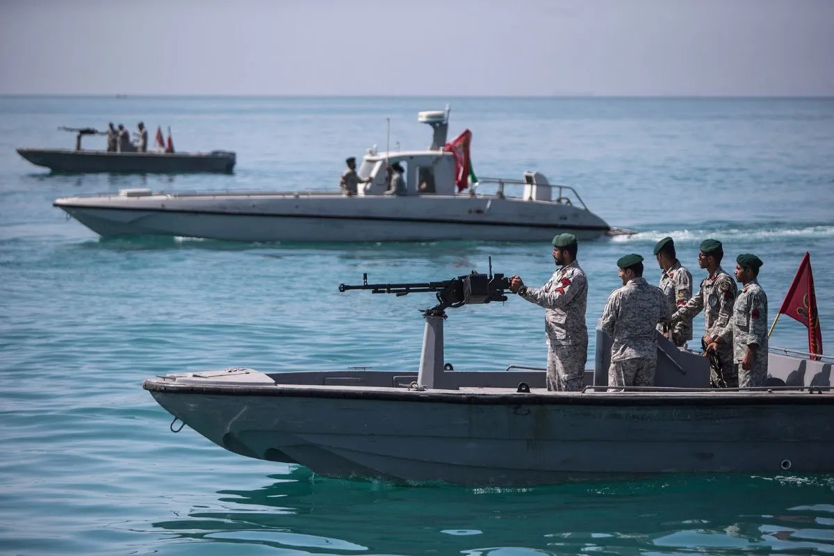
The water in the Strait of Hormuz does not look like a battlefield. From the deck of a commercial tanker, it is a shimmering, deceptive blue, occasionally broken by the white wake of a passing dhow. But beneath that surface, and screaming across the radio waves above it, a new boundary has been drawn. It isn't made of barbed wire or concrete. It is made of signals, radar pings, and a sudden, sharp expansion of Iranian presence that now stretches 500 kilometers beyond its old limits.
Consider a young navigator on a cargo ship hauling millions of dollars in liquefied natural gas. For years, the routine was predictable. You stayed in the shipping lanes, watched the coast of Oman to the south and Iran to the north, and kept your eyes on the radar. But recently, the "eyes" looking back at you have multiplied. Iran has integrated two new strategic regions into its surveillance net—the Jask and Shahid Kartas zones—effectively pushing their territorial watch far into the Gulf of Oman and the north of the Indian Ocean. Building on this topic, you can find more in: Why Italys three parent ruling actually makes sense for family law.
This isn't just about more boats in the water. It is about a psychological shift. When Tehran announces that they will "give blood but not land," they aren't just talking to diplomats in Geneva. They are talking to the sailors, the oil traders, and the global powers who treat this 21-mile-wide choke point as their personal highway.
The Architecture of a Choke Point
To understand why an extra 500 kilometers matters, you have to look at the geometry of global survival. The Strait of Hormuz is the world's jugular vein. One-fifth of the world’s oil passes through this tiny gap. If you squeeze it, the lights go out in cities thousands of miles away. Prices at a gas station in Ohio or a factory in Guangdong don't just rise; they explode. Analysts at The New York Times have shared their thoughts on this trend.
The Iranian military, specifically the Army’s Air Defense Force, has moved from a defensive crouch to an expansive reach. By bringing these new sectors under centralized "Mersad" and "Hafiz" surveillance systems, they have turned the entrance to the Persian Gulf into a high-tech lobby. You cannot enter without being seen, logged, and—if necessary—challenged.
The technology here is the silent protagonist. We often think of war as explosions, but modern sovereignty is defined by who owns the spectrum. Iran’s indigenous radar systems are now claiming to detect stealth aircraft and drones that were once thought to be invisible. When a radar operator in a darkened room near Bandar Abbas sees a "ghost" on his screen, the power dynamic of the entire Middle East shifts.
Blood and Soil in the Digital Age
The rhetoric used by Iranian commanders—the "blood for land" pledge—sounds like something out of a 19th-century history book. It is visceral. It is dusty. It smells of sacrifice. Yet, it is being applied to 21st-century electronic warfare. This contrast is where the real tension lives.
Why use such heavy, emotional language for a technical expansion of radar zones? Because in the eyes of Tehran, the maritime border is not a line on a map; it is a thermal layer of their national identity. They have watched for decades as foreign navies, primarily the U.S. Fifth Fleet, cruised these waters with a sense of permanent ownership. By expanding their "eyes" by 500 kilometers, Iran is effectively pushing the "front porch" of their house further into the street.
Imagine the perspective of a local fisherman. For generations, his family has navigated these waters using the stars and the shape of the cliffs. Now, his wooden boat sits in the shadow of massive Iranian destroyers equipped with long-range missiles. He is a witness to a transition: the sea is no longer a commons. It is a fortified corridor.
The Hidden Stakes of the 500 Kilometer Push
The expansion into Jask is particularly telling. Jask was once a sleepy port town. Today, it is a pivot point for Iran’s grand strategy to bypass the Strait of Hormuz itself if things go wrong. By building oil terminals there and extending their military surveillance even further out, Iran is creating a "Plan B."
But there is a catch.
When you expand your reach, you increase your friction. By monitoring two more massive sectors, Iran is now in direct electronic contact with a wider array of international vessels and aircraft. The margin for error shrinks. A misinterpreted signal or a drone that wanders too close to these new "sensitive zones" could trigger a chain reaction that no one actually wants.
The logic of the Iranian military is simple: deterrence through visibility. They believe that if they can see everything, no one will dare to strike. It is the panopticon of the sea. They are betting that by showing their teeth 500 kilometers away, they won't have to use them at the 5-kilometer mark.
The Human Cost of High-Frequency Tension
We talk about "geopolitics" as if it’s a game of chess played by giants, but the pieces on the board are human beings.
There is the drone pilot in a trailer in Nevada, watching a grainy feed of a dhow and wondering if the Iranian radar locking onto him is a bluff or a prelude. There is the Iranian technician, perhaps an engineering graduate from Tehran University, who spent months calibrating the "S-300" or its local variants, feeling a surge of pride—and terror—at the responsibility of holding the line.
Then there is the rest of us. We are the silent observers who only notice the Strait of Hormuz when the price of bread or gas spikes. We are tethered to these 500 kilometers of water by invisible threads of commerce and energy.
The Iranian commitment to "give blood" is a reminder that while we see a shipping route, they see a sacred perimeter. The expansion of their surveillance is a message to the world that the era of "open waters" in the Persian Gulf is being rewritten by the people who live on its northern shore.
As the sun sets over the Gulf of Oman, the new radar towers in Jask begin their evening sweep. Their pulses travel out over the water, bouncing off steel hulls and carbon-fiber wings, returning home with data that dictates the pulse of global stability. The line has moved. The stakes have grown. The shimmering blue water remains calm, but the air above it is heavy with the weight of a nation that has decided its borders are no longer where the land ends.
The silence in the Strait is not peace; it is the sound of a thousand sensors waiting for a reason to speak.