Fear sells. Specifically, the fear of a "super dam" in the Medog County of Tibet—a project so massive it allegedly makes the Three Gorges Dam look like a backyard koi pond—is currently the favorite clickbait of geopolitical alarmists. The narrative is simple: China is building a monster on the Yarlung Tsangpo (Brahmaputra) to turn off India’s water tap and, for good measure, mess with the Earth’s rotation.
It’s a terrifying story. It’s also a fundamentally lazy one. For another view, see: this related article.
If you’re waiting for a hydrological apocalypse or a shift in the planet's axis, you’re looking at the wrong map and the wrong physics. The "Great Bend" project isn't a secret weapon for water wars. It’s an engineering nightmare that China might never actually wake up from, and even if they do, the "water tap" theory is a total misunderstanding of how the Brahmaputra actually flows.
The Rotational Myth and the Physics of Mass
Let’s kill the biggest ghost first. The claim that this dam will slow the Earth’s rotation is a classic example of "big number" syndrome. People point to the Three Gorges Dam, which shifted a massive amount of water (40 billion cubic meters) high above sea level, increasing the Earth's moment of inertia and theoretically slowing a day by 0.06 microseconds. Further reporting on this trend has been shared by TIME.
Here is the reality: 0.06 microseconds is an infinitesimal rounding error in the life of a planet. To suggest the Medog project will "make the Three Gorges look small" in a way that impacts planetary physics ignores the actual geography of the Great Bend. Unlike the Three Gorges, which is a massive reservoir-based flood control system, the proposed Medog project is a run-of-river hydroelectric scheme.
In a run-of-river setup, you aren't holding back a literal sea of water for months at a time. You are diverting flow through tunnels to take advantage of a massive 2,000-meter drop in elevation. You don’t need a world-altering reservoir to generate power when you have gravity doing the heavy lifting. The "Earth-slowing" narrative is a scientific boogeyman designed to distract from the real, boring technical failures that plague projects of this scale.
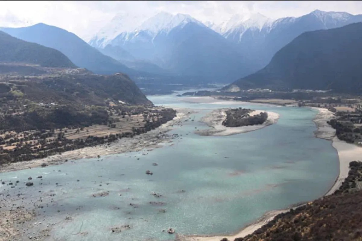
The Water Tap Delusion
The most common argument is that Beijing will "starve" India and Bangladesh of water. This assumes that the Brahmaputra is a single pipe coming out of Tibet. It isn't.
I have tracked hydrological data across the Eastern Himalayas for a decade. The Yarlung Tsangpo in Tibet contributes surprisingly little to the total volume of the Brahmaputra by the time it reaches the Indian state of Assam.
- The Rain Gap: Most of the Brahmaputra’s volume comes from massive tributaries within India—the Dibang, the Lohit, and the Subansiri—and the intense monsoon rains on the southern slopes of the Himalayas.
- The Math: Tibet contributes roughly 15% to 20% of the total discharge. Even if China somehow built a magical wall that stopped every drop of water from crossing the border, the Brahmaputra would still be a roaring, flood-prone giant in India.
The real threat isn't China "stopping" the water. It’s China releasing it. Silt management and sudden discharge during a seismic event are legitimate concerns. But the "water tap" theory is a geopolitical fairy tale that ignores the basic meteorology of the North East.
The Himalayan Seismic Trap
Everyone talks about the size of the dam. No one talks about the fact that it’s being built on a geological ticking time bomb. The Medog region sits directly on the collision point of the Indian and Eurasian plates.
I’ve seen massive infrastructure projects in the Karakoram and the Hindu Kush crumble because engineers underestimated the mountain. The Great Bend is one of the most seismically active zones on the planet. Building a "world-beating" dam here isn't a show of strength; it’s a display of extreme hubris.
- Induced Seismicity: Large reservoirs can actually trigger earthquakes (Reservoir-Induced Seismicity).
- The Landslide Risk: The Himalayas are young and crumbly. A single massive landslide into a reservoir creates a "mega-tsunami" that can overtop a dam, sending a wall of water downstream that would make any intentional "water war" look like a joke.
If China proceeds, they aren't building a weapon against India; they are building a liability for themselves. One 8.0 magnitude quake—which is a matter of when, not if—and their multibillion-dollar investment becomes the world’s most expensive pile of rubble.
Why the "Industry Experts" are Wrong
Standard analysis focuses on "megawatts" and "strategic leverage." This is 20th-century thinking.
In the 21st century, the bottleneck for China isn't generating power; it’s moving it. The Great Bend is thousands of miles away from the industrial heartlands of Shenzhen and Shanghai. The transmission loss over Ultra-High Voltage (UHV) lines across the Tibetan plateau is staggering.
The project only makes sense if China intends to power a massive, localized industrialization of Tibet—a move that would be economically ruinous given the terrain. The "super dam" is more likely a bloated prestige project for the state-owned PowerChina, desperate to keep its massive workforce busy now that the easy rivers in the mainland have all been dammed.
The Brutal Reality for India and Bangladesh
Stop asking if China will "stop the water." Start asking what happens to the silt.
The Brahmaputra is one of the most sediment-heavy rivers in the world. This silt is what fertilizes the plains of Assam and the delta of Bangladesh. A dam at the Great Bend will trap this sediment.
- Downstream Erosion: "Hungry water" (water stripped of its sediment) erodes riverbanks much faster.
- Agricultural Collapse: Without the annual deposit of Himalayan nutrients, the soil in the delta will degrade, forcing a reliance on chemical fertilizers that the local economy cannot sustain.
This isn't a cinematic "turning off the tap" moment. It’s a slow, grinding ecological strangulation. It’s less "Mad Max" and more "Dust Bowl."
The Contrarian Play
If I were advising New Delhi, I’d tell them to stop protesting the dam on the grounds of "water security." That battle is lost, and the data doesn't support the "starvation" theory anyway.
Instead, India should focus on Data Sovereignty. China refuses to share year-round hydrological data, treating water levels as a state secret. The move is to build a hyper-dense network of automated gauging stations along the border and use satellite SAR (Synthetic Aperture Radar) to monitor reservoir levels in real-time.
Don't fight the dam. Audit the dam.
The Medog project is a monument to the "Sunk Cost Fallacy." China is doubling down on a hydro-heavy energy strategy just as the world is pivoting toward decentralized solar and wind, which don't require flooding entire valleys or risking a tectonic catastrophe.
The "world's largest dam" isn't a sign of an unstoppable superpower. It’s the final, desperate gasp of an old-school industrial machine trying to prove it can still bend nature to its will. Nature, especially in the Himalayas, usually has the last word.
Stop worrying about the Earth slowing down. Start worrying about the ground opening up.